

About Me
Welcome to Alpine Atlas!
This is where the art of mapping meets the spirit of the mountains. ❤︎
I’m Lauren, a cartographer and GIS professional based in Southwest Colorado, blending precision, design, and adventure to create maps that inspire.
My Journey
I grew up in the Dallas-Fort Worth area with a lifelong fascination for maps and how they tell stories. That passion led me to study meteorology at the University of Oklahoma, where I discovered GIS and never looked back. After graduating, I moved to the mountains of Colorado to build a career doing exactly that.
For the past four years, I've served as the GIS Administrator for a Colorado mountain municipality where I design spatial data infrastructure, build public-facing web apps and dashboards, automate data pipelines, and lead a community trail wayfinding program from the ground up. I also hold a Graduate Certificate in GIS from the University of Colorado Denver and working towards my GISP certification.
Alpine Atlas is where the technical and the creative meet. Whether you need a beautiful custom map to hang on your wall, an interactive web map for your organization's website, or a full GIS data solution built on ArcGIS Online — I bring the same care and precision to all of it.
Let's build something worth looking at.

Work Experience
-
GIS Administrator & Addressing Coordinator
Mountain Village, CO
Develops, maintains, and ensures integrity of all Town geospatial data
Leads GIS projects and collaborates across departments to support planning, safety, and engineering
Produces detailed maps and administers GIS services for public-facing and internal use
Manages Town address updates and leads communication with agencies like USPS, emergency services, and utilities
-
GIS Intern for Aztec Ruins National Monument
Aztec, NM
Remapped historical structures using Leica GG04 GPS, ArcGIS Pro, Field Maps, and Survey123
Designed geodatabases and built domains with clear attribute schemas
Developed SOPs for data collection in a laser scan project
Projects
-
Town of Mountain Village
Assessed all Town addresses and identified those out of compliance with updated addressing standards
Re-addressed non-compliant properties and updated records with relevant entities (e.g., USPS, E911)
Coordinated with Town departments to minimize disruption and ensure smooth transitions
Facilitated public information sessions for neighborhoods to gather feedback and answer questions
-
Town of Mountain Village
Designed the Town’s summer hiking/biking and winter Nordic ski maps, incorporating cartographic best practices and Town branding
Co-developed trail sign and kiosk designs with the signage team for trailheads and intersections
Built an interactive 2D/3D web app to complement physical signage and display seasonal routes
Presenting to Town Council and Design Review Board for approvals and feedback
-
Town of Mountain Village
Researched plats and historical documents to identify acreage and zoning inconsistencies
Created a comparative report highlighting changes from the original 1995 plan
Presented findings to Town Council and corrected geodatabases accordingly
-
Town of Mountain Village
Developed and maintained Python scripts to automate GIS data pipelines, including REST-based data pulls, table joins, field updates, and publishing workflows to ArcGIS Online, reducing manual processing and error rates across core datasets.
Built automation tools to support municipal operations such as parcel data management, address readdressing, OpenGov permitting integrations, and routine updates to live web maps and feature services.
Implemented quality control and maintenance scripts (field validation, type normalization, link/status checks, batch updates of thousands of records) to ensure data integrity for public-facing and internal GIS applications.
-
Town of Mountain Village
Integrated datasets into AGOL from multiple departments to streamline cloud-based access
Built field maps for Parks & Rec and Public Works to capture real-time field data
Developed AGOL apps including Experience Builder, StoryMaps, FieldMaps, Instant Apps, and Survey123
-
Town of Mountain Village
Develop and maintain a connection between OpenGov permitting and the Town’s GIS systems to create more efficient internal workflows while reducing manual data handling and duplication.
-
Town of Mountain Village
Improved map templates by implementing modern cartographic styles and Town branding
-
Aztec Ruins National Monument
Captured and processed high-resolution 3D scans of historic ruins using the Leica BLK360 and Leica Cyclone software & authored a (SOP) for laser scanning workflows.
Professional Affiliations
-
Advocate for women in the GIS professional setting
Grow my professional network and offer mentorship to up and coming GIS professionals
-
Contribute to the weekly list-serve by answering various questions and interacting with fellow peers
Attend quarterly meet-ups to build relationships with GIS professionals in Colorado
-
Assist with running the quarterly zoom meet-ups by managing the discussions
Present GIS work I am actively completing or in the process of finishing
Maps I Designed
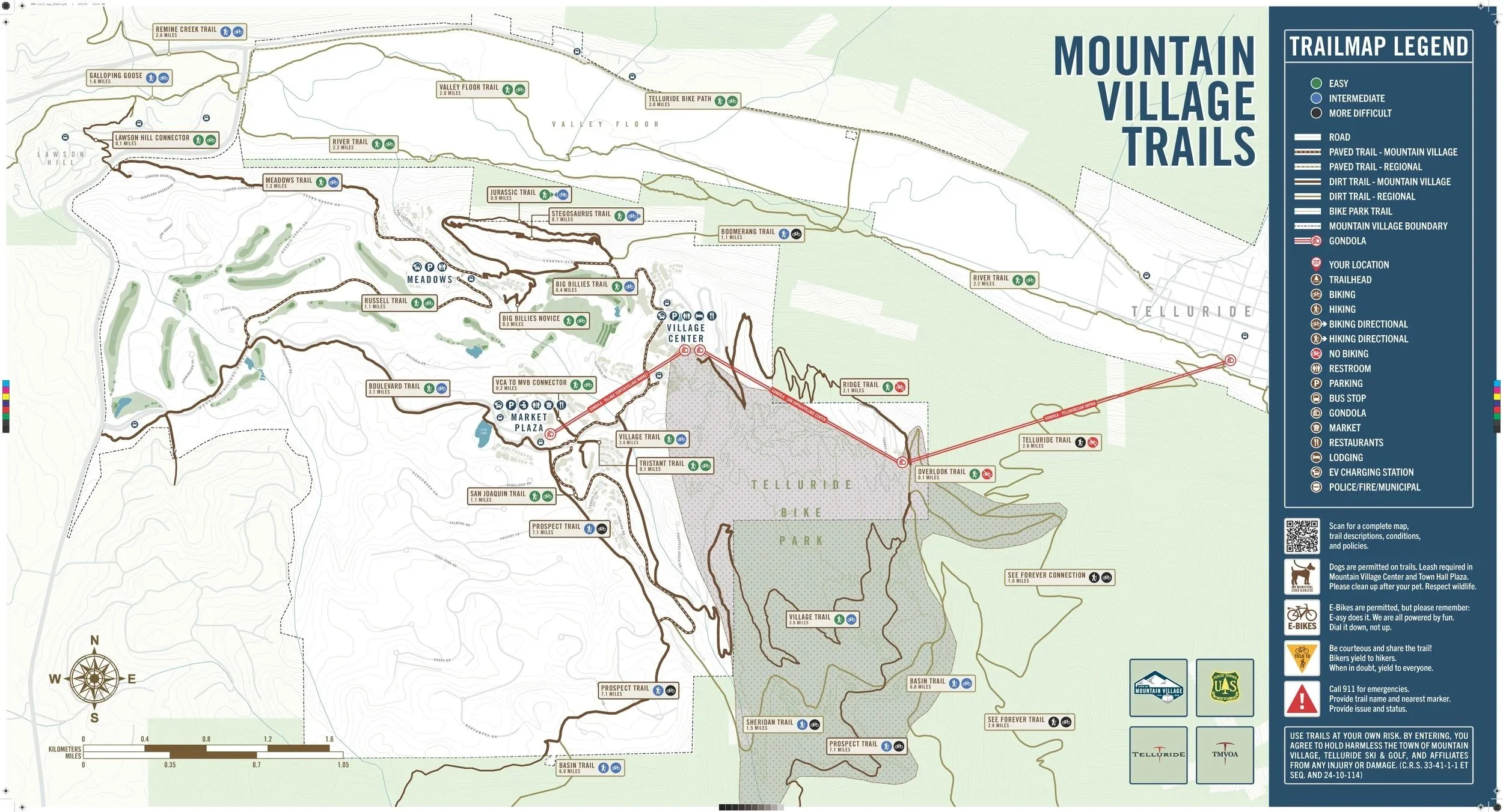
Town of Mountain Village Hiking & Biking Wayfinding Map
Designed for the summer trails wayfinding program
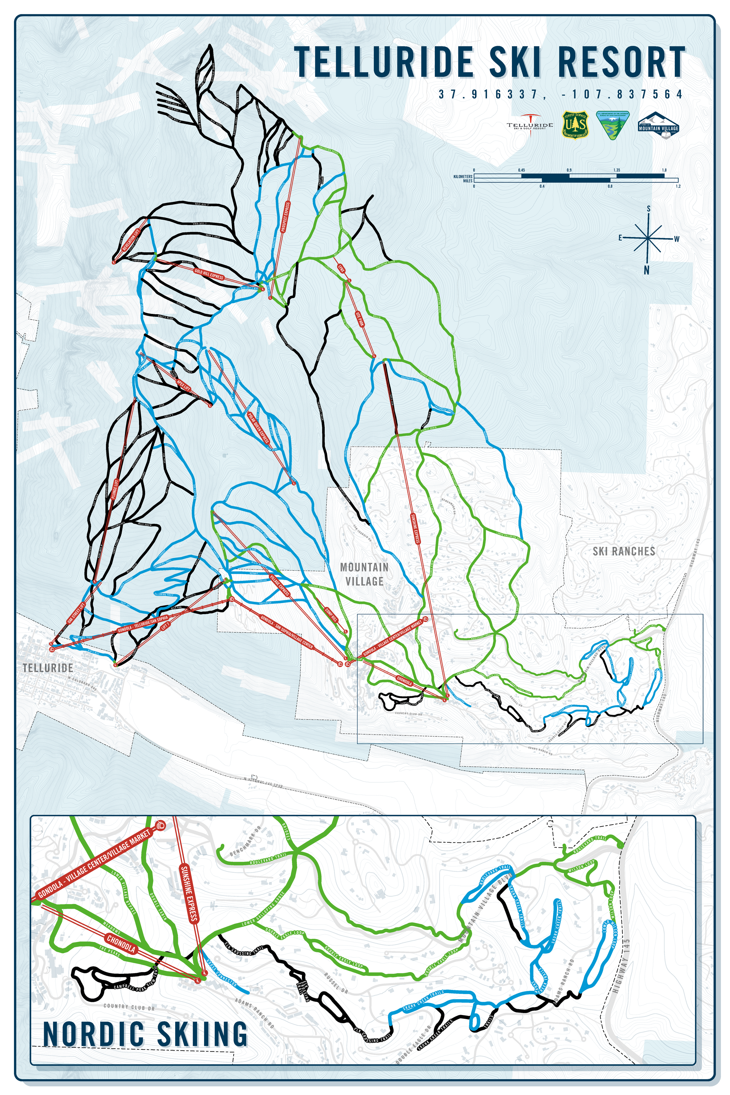
Telluride Ski & Golf Resort + Nordic Skiing
Designed for office use
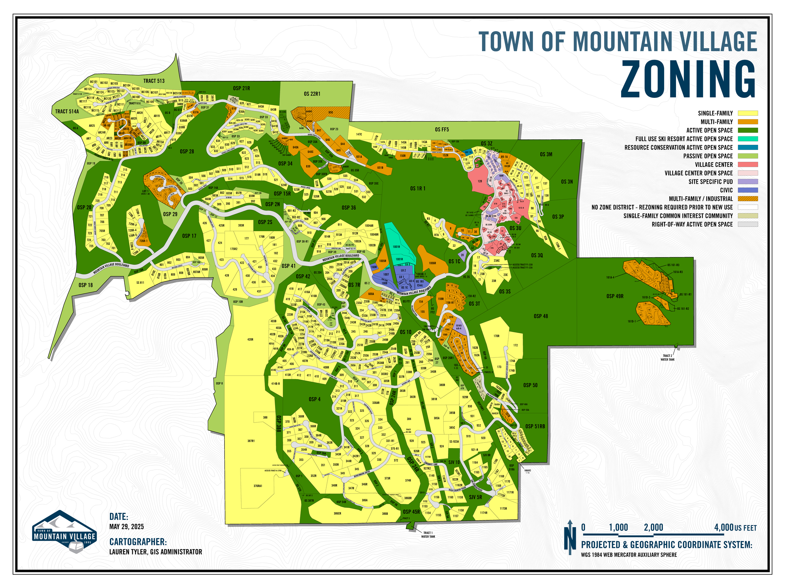
Town of Mountain Village Zoning Map
Designed for office use
Trainings & Certificates
GIS FOR CLIMATE ACTION | April 2024
ESRI MOOC course on how GIS is assisting climate action
ACCESSIBLE MAPPING | March 2024
State of Colorado OIT GIS accessibility guidelines
GOING PLACES WITH SPATIAL ANALYSIS | September 2023
ESRI MOOC course on spatial analysis techniques and best practices
ESRI USER CONFERENCE | May 2023 & June 2025
Attended seminars and training courses for new GIS technology and workflows
CARTOGRAPHY | October 2022
ESRI MOOC course on cartography tips and tricks
Technical Skills
ESRI ArcGIS Mapping Suite
ArcGIS Pro
ArcGIS Online
Experience Builder
Survey123
FieldMaps
StoryMaps
Dashboards
ArcGIS Hub
MyEsri
Instant Apps
Trimble Catalyst
Leica field mapping products
Python (including ArcPy)
Postman & API Documentation
Microsoft Office Suite
Adobe Acrobat
Inkscape
Canva Pro
Soft Skills
Team-oriented
Leadership
Troubleshooting
Public Speaking
Time Management
Detail-oriented
Education
CU DENVER | FALL 2023 - SPRING 2025
Graduate Certificate in Geographic Information Systems (GIS) & Geomatics
Designed to strengthen professional GIS skills and provide a foundation for advanced GIS study. The certificate consists of four graduate-level core courses (B- or better required) covering GIS fundamentals, project management, interactive web mapping, and geomatics. Can be completed as a standalone credential or as preparation for a master’s degree in GIS or engineering.
UNIVERSITY OF OKLAHOMA | FALL 2017 - SPRING 2021
Bachelors of Science in Meteorology & Minor in GIS
Completed a rigorous 120-credit meteorology curriculum emphasizing atmospheric processes, weather systems, dynamics, and climate, with hands-on lab and capstone experience. Coursework included atmospheric dynamics, physical meteorology, synoptic and mesoscale meteorology, measurement and observational systems, and research/communication methods. Built strong analytical and quantitative skills through supporting math and physics requirements, including calculus and physical mathematics. Additionally completed a minor in Geographic Information Systems (GIS), integrating spatial analysis and geospatial technology into interdisciplinary environmental science training.
UNIVERSITY OF READING, UK | SPRING 2020
Meteorology Exchange Program
Completed a semester-long international exchange focused on atmospheric science through a partnership between the University of Oklahoma School of Meteorology and the University of Reading in the United Kingdom. Gained global perspective on weather and climate systems, experienced meteorological education in a world-class UK program, and earned academic credit with approved course equivalencies toward the OU Meteorology curriculum.